


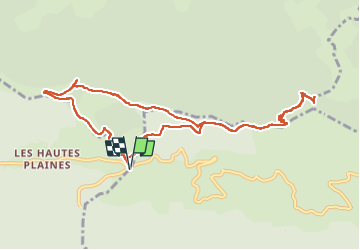
Col de Bauzon - Rocher d'Abraham

maupassant38
User

Length
11.6 km

Max alt
1526 m

Uphill gradient
466 m
Km-Effort
17.8 km

Min alt
1306 m

Downhill gradient
466 m
Boucle
Yes
Creation date :
2022-08-27 08:15:06.872
Updated on :
2022-08-27 14:27:10.247
3h30
Difficulty : Difficult

FREE GPS app for hiking
 SityTrail
IGN / Geographical institutes
SityTrail Plus
The world is yours!
About
Trail Walking of 11.6 km to be discovered at Auvergne-Rhône-Alpes, Ardèche, La Souche. This trail is proposed by maupassant38.
Positioning
Country:
France
Region :
Auvergne-Rhône-Alpes
Department/Province :
Ardèche
Municipality :
La Souche
Location:
Unknown
Start:(Dec)
Start:(UTM)
587040 ; 4942969 (31T) N.
Comments